Next Sketch Outing

Thursday, Sept. 4: Emerald Forest Theater
Showing posts with label Alaskan Way Viaduct. Show all posts

Friday, September 13, 2019

Via-chunk

Back in August of 2013, Urban Sketchers Seattle had an outing specifically to sketch the Viaduct as it was to be torn down soon. Well...

Today we sketched at the waterfront where the viaduct is mostly gone. It has been demolished over many months and some Seattle Sketchers have documented the process. I have not visited there since the demolition started so I was surprised at how open the area is now.

There are some still sections left and it was a popular subject today. We had 13 sketchers who braved Friday the 13th as well as possible rain. At the end we gathered around a statue of Ivar and his beloved gulls (more on that later).


Most of the sketchers stayed to share lunch obtained from the walk up Ivar's Fish Bar. Some of us went out to feed french fries to the gulls. Here's Tina offering some to one of gulls perched there for easy pickings.


I sketched this viaduct section in front of Big Fish Games, in the Maritime Building across from the ferry terminal. Himself referred to it as a "via-chunk" when I showed him the sketch later.


As I walked down the way from the light rail station, I took note of some scenes I might want to sketch. This Ivar's running clams weather vane caught my eye, out at the end of a pier. The Ivar's Acres of Clams restaurant and the walk-up window are just around the corner. 


Good-Bye, Viaduct; Hello, Fresh View

9/6/19 The last stump of the viaduct coming down.

It seems like we’ve been saying good-bye to the viaduct for a long, long time. Kate recalled a sketch outing at the waterfront in 2013 when we first started hearing news about the viaduct’s impending doom. I missed that one, but I began my own good-byes last December, when a few other sketchers and I got together to sketch the viaduct. Then there was the official farewell party and closure in February, when I walked on the viaduct for the first and only time.

Once the action got under way, I went back to sketch various parts of the viaduct in MarchAprilMay and June. Last week I went back yet again to sketch the last remaining stump (top of post), which is slowly being demolished even as I type this (viaduct demolition, it turns out, is not a bang but a whimper).

Enough already. I’ve said my good-byes, the viaduct is (mostly) gone, and it’s time to greet the bright view that is now visible after being hidden for decades behind that dark gray mass. Seattle USk did just that this morning, and it was refreshing to see familiar things in a new light – literally.

First I walked to the edge of a parking lot east of Alaskan Way to face west and sketch the Pier 55 building and some cranes behind it. Although this building is not particularly special to me, it’s the first time I’d seen it from that spot. Note the green Starbucks umbrellas in front of it . . .

9/13/19 Pier 55, Alaskan Way
9/13/19 Facing downtown from the waterfront

For my second sketch, I went to that Starbucks and faced east to sketch whatever buildings I could see from the outdoor table I shared with a couple of other sketchers (at right). It’s the same vantage point I had last December (below) – except now I could see the buildings. (And the same HUGE sale is going on next door.)

It’s a bright, new waterfront.

12/21/18 Here's how the same view looked last
December.

Thursday, May 23, 2019

Heavy Equipment Heaven

4/25/19 Viaduct demolition

It had been nearly a month since we were down at the waterfront to view ongoing demolition of the viaduct – it was high time to return and see how much progress had been made. We didn’t see quite the concentration of heavy equipment as last time (above); the machines were all still there, but undoubtedly scattered over a larger area moving north.

This time I got a closer view of the remains of three supports (below). Shredded rebar and other debris spilled out like veins from ripped limbs. I also got a better look at a lobster-clawed Ferma machine that I had sketched previously. It was busily gobbling up what looked like piles of black wire.

5/23/19
4/25/19

5/23/19
Meanwhile, my favorite photographer continued to document progress with his camera.

Sunday, February 3, 2019

Yet another Viaduct post


As you can gather from Tina and Ellie’s posts, urban sketchers have not escaped Seattle’s obsession with the Alaskan Way Viaduct and its closure. Yesterday we witnessed the “end of an era” final act: the new SR 99 tunnel officially opened and pedestrians had a unique chance to walk the new tunnel and the old dingy-with-oh-so-beautiful-views-viaduct before its final demise. 

The first of several "Goodbye Alaskan Way Viaduct" sketches - December 2018
Some of us have been sketching the viaduct for the past couple of months. I found its dark grey ugliness mesmerizing. Since I moved to Seattle, 3 years ago, I’ve been fascinated by the city’s contrast of beauty and ugliness: the Olympic Sculpture park and the corporate buildings of South Lake Union; the snow-capped mountains at the horizon and downtown’s ubiquitous construction zones; the beautiful waterfront and the ugly viaduct. 

A view of the Viaduct closed to car traffic from the back of the Pike Place Market - January 2019

I could not stop myself from sketching the viaduct once again, during the USK Seattle sketchwalk at the Seattle Art Museum on January 25

My Viaduct/Tunnel celebration day started at 6:30AM on February 2nd, when I took the bus to the Seattle Center to run the Tunnel to Viaduct 8K race. The race, as the name suggests, ran down through the new tunnel, up to the viaduct, down the old tunnel, and ended by the Seattle Center. 

Waiting for the race to start


It was the most crowded race I’ve attended in Seattle: 25,244 walkers and runners completed it (for comparison, less than 5,000 finished the Seattle Marathon and Half marathon this past November). There were also a record number of selfies taken in the tunnel and on the viaduct.

Runners making their way to water and food at the end of the Tunnel to Viaduct 8k Race. 

After the race, I sketched the view at the Seattle center as seen after crossing the finish line.


Throughout the day, 100,000 people showed up to walk the viaduct goodbye and to welcome the new tunnel. 
Before bowing to exhaustion and going home, I sketched a large image of Bertha hang on the tunnel operation buildings, which also features the four iconic yellow ventilation stacks. Bertha, the “world's largest earth pressure balance tunnel boring machine” was manufactured specifically for the SR 99 Tunnel and has cool steampunk look. Her starts, stops, and breakages have entertained Seattleites since 2013.
. 
A giant image of Bertha on a building. The four yellow cylinders are the tunnel's ventilations stacks. Raindrops create the mottled effect on the sketch. So Seattle.

Those yellow ventilation stacks on the tunnel's operation building are so iconic
It was starting to drizzle and I was cold and tired. Time to go home. 

Saturday, February 2, 2019

last exit on hwy 99

 Goodbye Viaduct and good riddance

I went out and sketched the viaduct a couple times in late December & early January to pull in a last view of the cars traversing it, before it closed. It's kind of a big deal that this structure is just going away, it's a huge piece of infrastructure and a main route for traversing the center city! As I've lived in Seattle for only a year and a half, I don't have the nostalgia about Alaskan Way that others do. I've only been on it maybe 5 times. To me, it's a toxic structure that makes all of the waterfront street below it kind of dark, dingy, and loud...generally unpleasant to be nearby. Further south in the West Edge, it's all empty buildings, trash strewn everywhere, and generally creepy vibes.

So to say the least, I was excited for the Viaduct to go away, but then I read that disheartening article in the Stranger about the new 6 lane road that will replace the elevated structure. Could it be possibly even worse than the highway?? I'll take that article with a grain of salt, but I'm not optimistic given how Seattle has dealt with its car culture til now.  I went out to document these views feeling a sense of duty to preserve how it is now - before it changes forever - and I realized that it's not especially beautiful or interesting. R.I.P.

A common refrain is how great the Viaduct views are, and how it was the "working people's view" of the waterfront. I get that it was a good view — I appreciate a good view!  As a non-driver, and someone who is strongly anti-car in general, I think the waterfront here should belong to the people, not to cars. And there are still plenty of spots to appreciate the vantages of Elliot Bay for free, and it's way easier to take it all in when you don't also have to concentrate on not crashing on the highway.

I think we're kind of spoiled for waterfront here in Seattle. If we put an ugly, loud highway down here, it's not a big deal, because you still have the other sides of Elliot Bay / Lake Union / Lake Washington / Puget Sound to look at...but this is the *central* waterfront. I think of Chicago's amazing lakefront bike path/excellent public spaces/beaches and dream of something along those lines for Seattle. I could go on, but ultimately I'm a newcomer who, unfortunately, compares everything to NYC (where I lived before here), and honestly I wish I could turn off that part of my brain.

Anyway, some drawings:


Standing at the lookout point by Pike Place Market, at Victor Steinbruek park. Mt. Rainier was partially out, completing the view. I enjoy the challenge of trying to capture the feeling of lots of cars going past - in this case by drawing some in water soluble media, then running a water brush over it to fade them out, then drawing on top of that to simulate a long exposure in photography. 
  • I'm showing this one & the very first piece at a Viaduct-themed show at the newly opened Phantom Realms gallery, which is appropriately located under the Viaduct (for now!). The opening is on Thursday 2/7 (Pioneer Square artwalk night). 


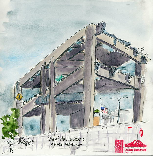
Standing under Seneca St ramp in an empty parking lot. So many good, dynamic views around this thing, maybe I'll make it back for a final sketch before they remove it! I bet the people who live/work in these buildings can't wait for this highway to go away. I'm sure this stretch will look really different in 10 years. Betting on there being several more luxury apartment buildings than there are currently.


 Walking on the Viaduct 

Like many of us, I went to the festivities on Alaskan Way. I was expecting long queues and crushing crowds, but it wasn't that bad - I appreciated that even though you were supposed to reserve a ticket to enter, the staff weren't even checking for them by the time I got there. I entered at the north hub by the old tunnel and had to wait for my companion, who I accidentally ditched as we biked over, so I sketched the pedestrians entering & leaving the tunnel. It was kind of surreal. The feeling I got was : why can't it always be this nice?


The event was a good time. I thought the curation of the art pieces was very thoughtful and represented the best of Seattle culture. Everyone seemed just down to appreciate the views and the interesting perspectives of spots you only get a glance of when you drive on this route. I saw people spray painting inside the old tunnel, and others hacking at the potholed pavement with chisels and pliers to attempt to take pieces of it away as souvenirs. It seemed to not work very well.

I kept overhearing folks wishing we could somehow keep the viaduct and tunnel and repurpose them into...a pedestrian/bike-friendly path! a High Line style elevated park! a mushroom farm (the tunnel)! I get that it's not safe in the event of the Big One but it still seems like a big waste to just throw away these huge infrastructure projects.
 A final sketch while my companion waited in line at the port-a-potties. The special vantage of looking at the Seneca St. ramp from the highway! I kept thinking: "this moment is special. it will never happen again." I really felt like part of the city today at this event. Everyone has their own memories and experiences with this thing - for many Seattleites, it's been around their whole lives, and the nostalgia is totally understandable. I just hope with its removal, something substantially better can replace it.

The Viaduct: Concrete, Potholes and Nostalgia

2/2/19 Hundreds of thousands of pedestrians walk on the Alaskan Way Viaduct.
On our final day of driver’s ed, my car mates and I were supposed to drive on Interstate 5 to show that we could merge and achieve freeway speed safely. When it was my turn, however, my instructor wasn’t confident that I could drive at 55 mph safely, but he apparently thought I could handle 45 on Highway 99 instead. It was the first time I had ever driven on the Alaskan Way Viaduct.

Since that summer of 1975, I have driven on the viaduct countless times, safely but often mindlessly. As a Seattle native, I usually took for granted the glorious views of Elliott Bay, the Olympic Mountains and downtown Seattle that the viaduct offered. For me, it was just a way to get from point A to point B – an often convenient and faster alternative to I-5. It was Greg, a Midwest transplant, who taught me to appreciate the viaduct whenever he deliberately chose that route just for its views.

On the day before its closure and eventual destruction, we took a drive for one last glimpse of that view and to say good-bye to the viaduct. (I made my farewell sketch of it from the waterfront in December a few weeks before it closed.) I’m not exactly teary-eyed to see it go; dark, noisy and unsightly from the ground, the viaduct is a formidable barrier between our city and its waterfront. Built in 1949, it’s also a scary seismic risk. Still, it’s part of the city’s history and my personal history.

On Feb. 2 we got one more chance to bid farewell to the viaduct, this time in a way that has never been possible before: without a car! The public was invited to participate in a “community celebration” that allowed pedestrians to walk on the viaduct for the first and only time.

Along with 100,000 other people, Greg and I first walked partway through the new tunnel that will convey traffic in place of the demolished viaduct. I wasn’t very interested in seeing that part, but I figured it was as clean as it will ever be!

The new tunnel that will take the place of the viaduct

Next we walked through the old Battery Street Tunnel, which will be filled with rubble. It was eerie to be on foot in the 2,000-foot tunnel that I had driven through so many times. (Years ago, I had to slam on my brakes to avoid hitting a poor, flustered dog that had wandered into the tunnel. Several cars squealed to a stop behind me as I somehow avoided getting rear-ended.)

Entering the old Battery Street Tunnel

Light at the end of the Battery Street Tunnel
Finally, the light at the end of the tunnel got brighter, and we walked onto the open viaduct. A woman nearby pointed to the Western Avenue exit and got a bit emotional as she exclaimed to her companion, “I’ll never take that exit again! I took it every day to get to. . .” He took her photo near the exit.

Walking south on the viaduct


It was fun and somewhat disorienting to be able to leisurely enjoy the views I’d zipped by so many times at freeway speeds. A bit overwhelmed, I couldn’t seem to get a bearing on what to sketch. I could have chosen one of those beloved city or waterfront views. But the really strange and wonderful part about the day was simply walking on the viaduct with so many other people. When we neared the Pike Place Market, I finally saw the sketch I wanted to make. I bellied up to a ribbon barrier where I could see thousands and thousands of pedestrians passing the market’s parking garage as the viaduct snaked southward.

Walking past the Pike Place Market from below.
I didn't see any sketchers I knew. This artist must have made special arrangements to get this seat!

These people were all waiting to walk onto the viaduct as we were leaving. The line went down several blocks.

Bye-bye, viaduct! 

Friday, December 21, 2018

A Chilly Farewell

12/21/18 Farewell, ugly viaduct!

We’ve all known for years that the viaduct would be demolished in early 2019. I could have chosen any warm fall day to do it, but instead, I waited until it was 39 degrees to make my farewell sketches.

12/21/18 After being chilled to the bone making the
first sketch, I retreated to Starbucks for this window sketch.
We all have a love/hate relationship with the dark, formidable viaduct, but however we might feel about it, it’s coming down in February.

Walking under the viaduct toward the Pier 55 Starbucks where I was meeting Sue and Antonella on this chilly morning, I passed many people in small tents or nothing but sleeping bags; they use that viaduct as their rooftop each night. Feeling my fingertips go numb as I sketched, I wondered where they would go when their “home” disappears in a couple of months.

I think the only other sketch I have of the viaduct is one I made from the ferry terminal walkway three years ago.

By the way, the scope of the top sketch is very ambitious for me, and I was quietly freaking out as I blocked in the composition. But I remembered what I learned in Gabi Campanario’s “Pocket Urban Sketching” workshop a couple of years ago, which helped immensely.

Sue and Antonella braved the cold to sketch with me.


Farewell Viaduct


I think this is the first time I have ever sketched the Seattle Viaduct, and sadly, it is also the last time. Scheduled to be torn down in early 2019, it will be replaced with a shiny new tunnel. I met up with Sketchers Tina and Antonella this morning to commemorate the last weeks of this Seattle icon. I have driven on the viaduct many times, and I know that many Seattlites are taking “last” drives through town on it, documented with photos and video. But this is the view I will keep in my memory.

Thursday, August 22, 2013

Under the viaduct

I took last weekend's location literally and located myself UNDER the viaduct.  The sketch below faces west where you can see a peek at what will be panoramic in the near future. 


This scene is on the same street, directly up from Starbucks. It's a juxtaposition of the underworld with it's graffiti wall painting and the upper world up the stairs that lead to first avenue.


 I really liked this sketch location. It had a lot of variety. And what amazing talent in our group!

Sunday, August 18, 2013

Day at the Viaduct

This ramp at Seneca seemed to illustrate how negatively this structure has impacted our waterfront and the cool buildings in the neighborhood. 

Friday, August 16, 2013

August Sketch Outing - Under the viaduct, Seattle Waterfront


Join us for the August Sketch Outing

Sunday, August 18: Under the viaduct, Seattle waterfront

10:00 am to 12:30 

Meet at the Starbucks on Alaskan Way and Spring (map)

10:00 a.m. 


Saturday, October 22, 2011

Alaskan Way Viaduct

I thought I would do a sketch of this section of the Alaskan Way Viaduct before it comes down. It will be interesting to watch how the landscape changes during the nine-day "Viadoom" closure of the highway.